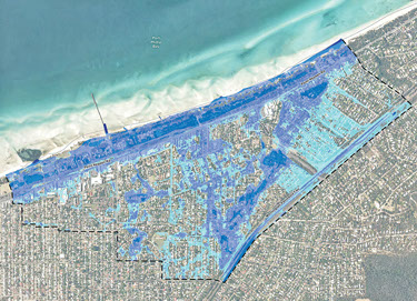
A BLUEPRINT to cope with climate change flooding in the Rosebud and McCrae area in the short term and over the next 90 years has been released.
The Port Phillip Coastal Adaptation Pathways Program states the benefits of “occupying the hazard zone, derived from its use by residents and businesses, is valued at about $35 million a year between now and 2100” and Mornington Peninsula Shire should start spending money to adapt to predicted sea level rise and significant flooding caused by extreme rainfall.
The adaptation program studied four bayside areas – Rosebud-McCrae, Mordialloc, Elwood and Southbank as well as a low-lying area in North Melbourne.
Elements of the report were reported by The News last November (“Rosebud 2010 flood risk”, 1/11/12) including that it could cost $100 million to protect Rosebud and McCrae.
Last September, shire CEO Michael Kennedy told councillors the gap between the cost of retreat and adaptation was so great “it’s not a tough call”. Adaptation was the cheaper option. The study said it would cost $100 million to adapt “but we say it is less”.
The report came to light last year after shire councillors held a private meeting that was accidentally taped and put on the shire’s website.
The adaptation report states the cost of coping with flooding could be $9 million a year if the shire does nothing now.
The Murray-Anderson Catchment spanning Rosebud and McCrae was the area chosen by the shire for the study.
It is about 274 hectares and contains 2605 properties, mostly homes with some commercial properties along the foreshore.
The study says the catchment “currently experiences significant flooding (covering more than 74 per cent of land parcels) predominately as a result of extreme rainfall in the local catchment, which is expected to increase in extent and depth as a result of climate change”.
The predicted flooding has implications for construction of homes and commercial buildings on or near the foreshore, including the proposed Southern Peninsula Aquatic Centre planned for the Rosebud foreshore near Rosebud Memorial Hall.
The study says that without adaptation, “the current cost of flooding is expected to increase from over $7 million to more than $9 million per year under the assumed climate change scenario”.
“As such, the annual value of occupying the hazard zone by 2100 is three times greater than the expected costs of flooding.
“For this area, the most economically favourable adaptation pathway is to improve resilience to current flood events while reducing risk from the current 100 year ARI flood events.
“ARI is average recurrence interval, the expected time between the events that exceed a given value (for example rainfall or wave height). Also referred to as the ‘return period’, it is usually expressed in years. For example, the 1-in-100 year rainfall experienced during a storm event will on average only be exceeded once every 100 years. However, it does not mean it cannot happen more, or less, frequently than every 100 years.”
Maps in the study show flooding in large areas of Rosebud between Jetty Rd and Lonsdale St, and parts of McCrae east of Lonsdale St.
This would occur during a “perfect storm” of coastal flooding combined with heavy rains when stormwater would not flow into Port Phillip.
The study contains a cost-benefit analysis of whether to “retreat” or “adapt” as sea level rises, storms increase and more heavy rainfall events occur.
Suggestions in the study include:
Increase the height of Mornington Peninsula Freeway to act as a flood barrier for runoff coming from Arthurs Seat.
Improve shire and community awareness, preparedness and recovery from flood events.
Continue to improve drainage in conjunction with Melbourne Water. “This is likely to be the most cost-effective approach to reduce current and future flood risks.”
Protect or move “a number of critical community assets” in the hazard zone. “Damage or loss of these assets will affect key public services and amenity.”
Future flood risk should be considered in council’s planned changes to LSIO [land subject to inundation overlay] boundaries.
Roles and responsibilities for adaptation need to be defined between relevant organisations, including state and local government. Responsibilities will change over time as the impacts of climate change become more severe.
Regular monitoring and review of inundation risks should be integrated into existing council strategies and plans, including climate change action plans, drainage management plans, municipal strategic statements and precinct plans.
“This analysis supports the decision that retreating from the entire study area is not a viable adaptation approach,” the study says.
“However, a similar economic analysis at an individual land parcel level may provide different results and therefore retreat at the micro level may be appropriate to consider for higher risk areas.”
The study was prepared for the Municipal Association of Victoria with the cooperation of councils and funded by the federal government’s Department of Climate Change and Energy Efficiency.
Last year the government’s climate change department said almost 250,000 coastal homes worth more than $60 billion were at risk of flooding from sea level rise over the next 90 years


