


A DRAFT plan with the ultimate aim of “enhancing and protecting the Mt Martha coastline” has been released for public discussion.
Recommendations in the plan include producing brochures so coastal property owners “understand the benefits to the foreshore reserve in the removal of environmental weeds from their properties”.
The necessity for this education campaign becomes clearer when reading parts of the report which call for the closure of “ad hoc goat” tracks behind beach boxes and an end to “vegetation vandalism” to create bay views.
Other recommendations in the draft plan are aimed at combating erosion as well as introducing drop-off zones to reduce congestion in foreshore car parks at Mt Martha Beach South and Mt Martha lifesaving and yacht clubs.
It seems Mt Martha’s foreshore has become a victim of its own popularity.
The draft plan states the shire’s intention to be “respectful” in its dealings with “local indigenous elders” to preserve the heritage of the area.
This will include deciding how best to “protect and prevent unlimited access to the shell middens along the foreshore reserve”.
Middens are exposed and have for years been crumbling along much of Mt Martha North and Hawker beaches.
The plan also calls for the shire to investigate the impact of the sea level rise of 0.8 metres by 2100 on the Mt Martha foreshore.
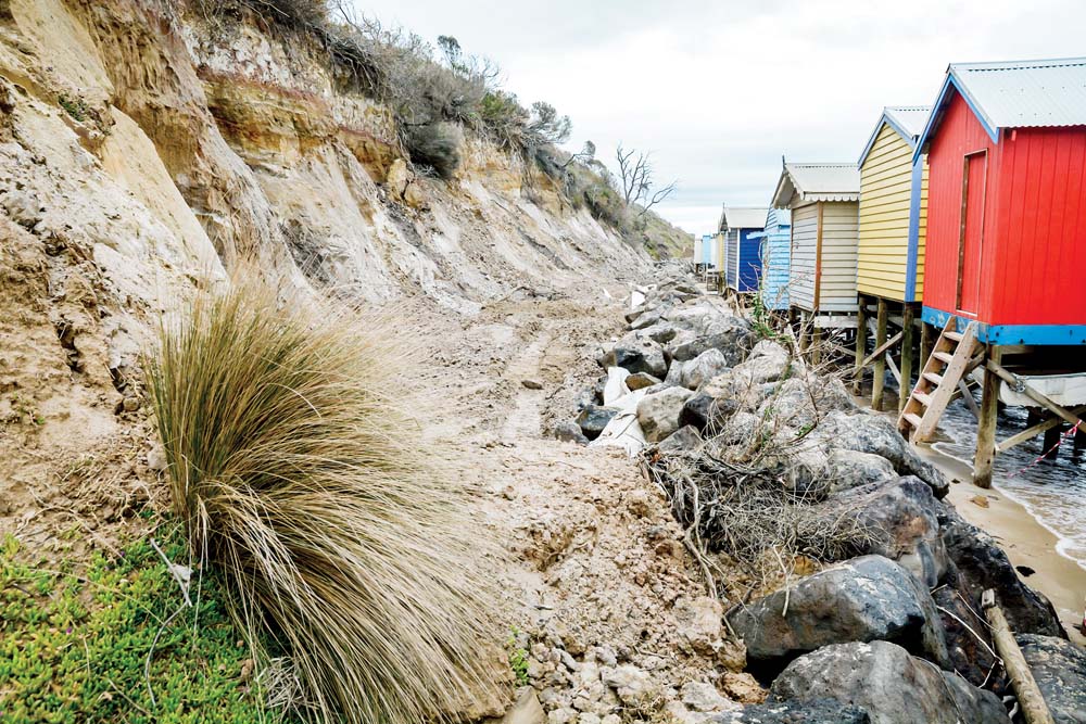
Hundreds of thousands of dollars was spent last year on shoring up crumbling cliffs at Mt Martha Beach North and the owners of threatened beach boxes are lobbying for a rock groyne to be built in the water which, they say, will bring sand back to the beach.
The plan also says the shire will continue to regulate dog owners using the foreshore. This declaration comes in the wake of revelations by The News that for some years the shire had incorrectly warned dog owners off an area of beach, which in fact was part of the leash-free Hawker Beach.
Further north, the shire wants to draw up a landscape plan for Fossil Beach and protect the remains of a cement works “and the multitude of fossils in the limestone cliff that show evidence of Australian sea life from 10-15 million years ago”.
The shire will also seek finance for an “interpretive sculpture project along the Nunns Walk telling the European and indigenous story of the local area”.
Already under fire from some quarters for erecting a temporary fence along the Esplanade to impede access to The Pillars cliff jumping site (which has its own evolving long term management plan), the draft foreshore plan recommends more foreshore fences to limit parking, the spread of weeds and to combat erosion.
A news release issued by the shire says the draft Mt Martha coastal management plan is designed “to protect and enhance the unique natural and cultural heritage of the Mt Martha foreshore reserve for present and future generations to enjoy”.
It states that the plan “provides strategic direction for the vision and future management” of the 10 kilometres of foreshore reserve from Linley Point in the north to Martha Point in the south.
The Cr David Gill said the shire has a “strong interest and long-standing commitment to being leaders in coastal planning and management”.
“The coastal management plan establishes an agreement between the Victorian government, Mornington Peninsula Shire and the community as to how the foreshore reserve will be managed,” he said.
The plan can be seen at mornpen.vic.gov.au/haveyoursay or inspected at the shire’s Rosebud, Mornington, Hastings and Somerville offices. A public meeting will be held 4pm-6pm Wednesday 20 February at Mt Martha Life Saving Club.
Submissions close Sunday 3 March and can be emailed to: haveyoursay@mornpen.vic.gov.au with the subject line Mt Martha Coastal Management Plan.


