


RISING sea levels will pose a huge risk to the coastlines of the Mornington Peninsula and Frankston this century, according to a state government-commissioned report.
The Port Phillip Bay Coastal Hazard Assessment report published last week assessed potential damage to the bay’s coastlines if sea levels rise by 1.4 metres.
It listed the area around Martha Cove, the Balcombe Estuary recreation reserve at Mount Martha and the foreshore from Rosebud to Dromana as being at risk of inundation once sea levels rose.
Patterson Lakes is one of the areas most at risk on the eastern side of Port Phillip, according to the Commonwealth Scientific and Industrial Research Organisation.
“The highly urbanised and low-lying areas of Greater Geelong, Werribee, City of Port Phillip and Mordialloc to Frankston were deemed most at risk from hazards posed by sea level rise,” the report stated. “For the Borough of Queenscliffe and City of Bayside the area of inundation approximately doubles between present conditions and 1.4 m of sea level rise whereas for the Cities of Hobsons Bay, Greater Geelong, Frankston and Mornington Peninsula Shire the inundation area undergoes an approximate two to three-fold increase for a 1.4 m sea level rise.”
The CSIRO report states that the Kingston Council area faces a “tenfold” inundation risk if the 1.4 metre sea level rise model is applied. It read that some parts of the Kingston Council area were not properly equipped for that scenario. “Much of this increase occurred in the Edithvale-Seaford Wetlands between Mordialloc Creek and Patterson River indicating that existing coastal protection structures would not be effective for 1.4 metre sea level rise.”
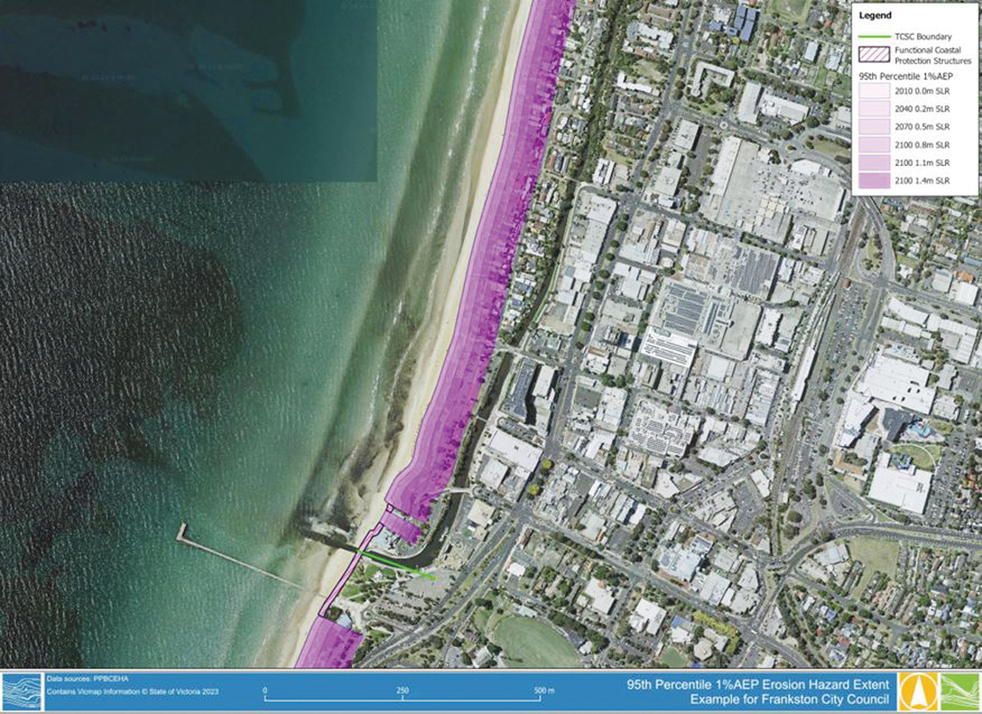
A map of the potential impacts of a 1.4 metre sea level rise by 2100 shows all of Frankston beach at risk of erosion.

After the report’s release the Prime Minister Anthony Albanese told a news conference that “the first thing that we have a role in is enacting on climate change”.
“My government is taking serious action on it. Of course planning is the responsibility of state governments, but we work cooperatively with governments of all persuasions to work through these issues,” he said. “We have a government that is committed to action on climate change and an opposition that, in spite of the evidence that we see with the science and warnings that we were told about, of more extreme and more regular and more intense extreme weather events, nothing seems to have woken up the Liberal and National parties in Australia to this.”
The state government said it had spent $1.8 million “to support local governments and land managers to progress adaptation planning studies in the Port Phillip Bay area, with the release of the Coastal Hazard Assessment to support progression of these projects.”
Environment Minister Steve Dimopoulos said “the Port Phillip Bay Coastal Hazard Assessment will be used to help local authorities and Victorians make better informed decision around our changing coastal environment”.
“Victoria’s precious coastline is already being impacted by climate change. Our focus is on managing the risks, adapting to the changes, and supporting communities and industries to be resilient,” he said.
To read the full report visit marineandcoasts.vic.gov.au/coastal-programs/port-phillip-bay-coastal-hazard-assessment


