A TRACK leads down to rocky ledges below the site of the latest landslide on the Esplanade between Mt Martha and Safety Beach.
The jagged rocks are partly covered by bright orange lichen and the clear water gurgles up and down as a westerly wind chops up Port Phillip.
The landslide itself has uncovered what appear to be the remains of a rock retaining wall built into the cliff as well as undermining the bitumen road.
It may have also revealed, or swept away, traces of people who lived here long before Europeans set foot on the shores of a bay they would name Port Phillip.
VicRoads says the 4 June landslip is a registered cultural heritage site “with evidence of shell middens”.
Shell middens are described in a Department of Planning and Community Development brochure as containing the remains of shellfish eaten by Aboriginal people, sometimes from a single meal or many meals eaten in the same location over many years.
“Charcoal and hearth stones from fires as well as other cultural items such as stone and bone artefacts can also be present.”
The department’s map of Areas of Cultural Heritage Sensitivity in Victoria includes most of the Mornington Peninsula’s coastline.
Under the Aboriginal Heritage Act 2006 a cultural heritage management plan (CHMP) must be approved by Aboriginal
Affairs Victoria before VicRoads can begin work to reopen the Esplanade.
Mornington MP David Morris has asked the Minister for Aboriginal Affairs Jeanette Powell to help speed up the repair of the road (‘Call to fix coast road’, The News 18/9/12).
Previous landslides on the Esplanade over the past two years have been repaired without such a plan, as was work to combat erosion at Mt Martha Beach North.
The work at the beach involved “shaving” the clifftop where Aboriginal middens had been identified.
However, a CHMP was required before work began on the beach near Gulls Way, in Daveys Bay, Mt Eliza.
The Esplanade itself has been hacked into the side of the hill in a cut-and-fill operation, leaving rocks exposed and small creek valleys filled, usually with a culvert delivering excess water straight into Port Phillip.
VicRoads says the landslide occurred at the mouth of Sheoak Creek, a waterway that has its beginnings near the summit of Mt Martha and which runs mainly after rains.
Next to the landslide, anglers try their luck from the rocks, casting into the deeper water clear of potential snags.
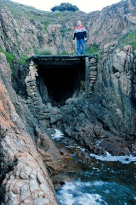
Steps cut and then faced with concrete lead to a wider inlet between rocky outcrops within which nestles a concrete-roofed structure that could have been used as a boat shed.
The natural, rocky floor of the structure is above the high tide mark, but only just. The entrance is formed by rocks cemented to form pillars, narrowing its width and providing protection for anything stored within.
Historian Winty Calder in her book Mount Martha Lands and People suggests the boat sheds were built in the 1920s, possibly by people operating a “rough and ready holiday camp” on the headland later used as a municipal quarry.
The “guesthouse” was known as The Allies, but could be reached only by foot along a track that would become the Esplanade.
Ms Calder says stones had been removed from the small channels leading to “the extraordinary boat shed”, giving access to flat-bottomed boats.