Close Menu
  • Home
  • News
  • Sport
  • Entertainment
  • Local History
  • Contact Us
  • Advertise With Us
  • About Us
  • Subscribe
  • Read Our Newspapers Online
    • Read the Latest Western Port News
    • Read the Latest Mornington News
    • Read the Latest Southern Peninsula News
    • Read the Latest Frankston Times
    • Read the Latest Chelsea Mordialloc Mentone News
  • Competition
  • Home New
Facebook X (Twitter) Instagram
Wednesday, July 2
Breaking News
  • E-bike rider charged following fatal collision in Hastings
Facebook X (Twitter)
MPNEWSMPNEWS
  • Home
  • News
  • Sport
  • Entertainment
  • Local History
  • Contact Us
  • Advertise With Us
  • About Us
  • Subscribe
  • Home New
Breaking News
MPNEWSMPNEWS
Home»News»Land move for core part of port planning
News

Land move for core part of port planning

By Keith PlattFebruary 11, 2014Updated:August 3, 2022No Comments2 Mins Read
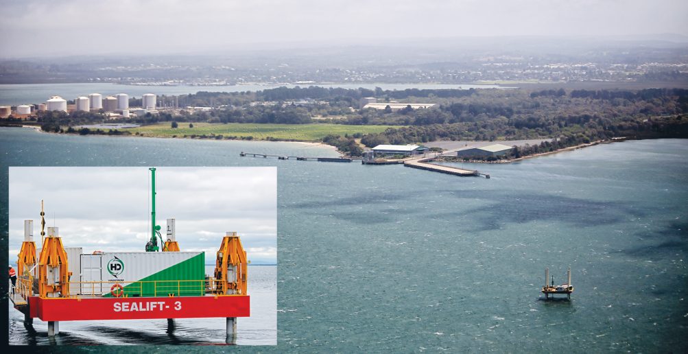
Survey points: Drilling sites on land and sea are shown in purple on a map produced by the Port of Hastings Development Authority, left; above, the drilling rig in place off the BlueScope jetty near Hastings.
Share
Facebook Twitter LinkedIn Pinterest Email

SOIL samples and surveys began this week on land likely to be used for the planned expansion of the Port of Hastings.

The 30 drilling sites are just north of Hastings within the BlueScope Steel area and around Whitneys Rd, Somerville.

Core sampling and surveys have been underway in Western Port since December, mostly in the proposed port area and North Arm channel, and will now continue throughout all survey areas, including the Western Channel and anchorage.

Port of Hastings Development Authority CEO Mike Lean said the survey results would provide “detailed knowledge on the soil composition, geological characteristics and topography in areas of the existing port-related special use zone (SUZ1)”.

“The marine and land-based site surveys will provide the critical baseline information needed to inform port design and detailed scientific studies over the next three to four years of detailed planning for an expanded container port at Hastings,” Mr Lean said.

He said the land surveys were planned over the next two to three months and would not be carried out on days of total fire ban.

“Since mid-December 2013, specialist contractors Worley Parsons and Aurecon have completed about 50 per cent of the marine geophysical survey and about 20 per cent of the marine geotechnical survey,” Mr Lean said.

Share. Facebook Twitter Pinterest LinkedIn Tumblr Email

Related Posts

Railway station scam

July 1, 2025

Flinders result unaffected by poll blunder – AEC

July 1, 2025

Grand Hotel’s tower revamp signals new chapter for icon

June 26, 2025

McCrae telco tower refused over visual impact

June 26, 2025
Add A Comment
Leave A Reply Cancel Reply

You must be logged in to post a comment.

Peninsula Essence Magazine – Click to Read
Peninsula Kids Magazine – Click to Read
Letters to the Editor
Property of the Week

14 Bass Street, McCrae

June 3, 2025
Council Watch

Shire secures $3.9m to tackle road safety

June 16, 2025

Kinder flyer flag snub prompts councillors to take over

June 10, 2025
100 Years Ago This Week

Baxter – On The ‘Wallaby’ with a walking group

July 1, 2025
Interview

Firefighter shows skills from sea to snow

February 5, 2024
Menu
  • Home
  • News
  • Sport
  • Entertainment
  • Local History
  • Contact Us
  • Advertise With Us
  • About Us
  • Subscribe
  • Home New
About

Established in 2006, Mornington Peninsula News Group (MPNG) is a locally owned and operated, independent media company.

MPNG publishes five weekly community newspapers: the Western Port News, Mornington News, Southern Peninsula News, Frankston Times and Chelsea Mordialloc Mentone News.

MPNG also publishes two glossy magazines: Peninsula Essence and Peninsula Kids.

Facebook X (Twitter)
© 2025 Mornington Peninsula News Group.

Type above and press Enter to search. Press Esc to cancel.