
STRICTER planning rules are likely to be brought in for land around Western Port threatened by rising sea levels.
The need to add a “land subject to inundation” (LSIO) overlay to the Mornington Peninsula’s planning scheme follows the release more than two years ago of a report identifying areas that will be affected by coastal erosion, flooding, sea level rises and storm surges.
The updated report identifies 710 properties that need to be covered in the overlay, including 136 houses at Hastings, 85 at Balnarring Beach and 13 at Somers.
There are 40 commercial properties facing clouding at Hastings and one each at Somerville and Crib Point.
At Flinders, Shoreham, Point Leo, Merricks Beach and Bittern the land under threat is mainly rural or included in public reserves.
The report also warns that underground water supplies will increasingly be salt affected.
“The balance of properties are community uses, infrastructure facilities, reserves, caravan parks, marinas or rural land,” Mornington Peninsula Shire’s planning services team leader Rosa Zouzoulas says in a report to this week’s Planning Services Committee meeting.” Ms Zouzoulas recommends that the shire asks the Planning Minister Richard Wynne to support the proposed amendment to the peninsula’s planning scheme.
She says adopting the overlay could reduce “events [that] can severely disrupt communities and in extreme cases, cause extensive damage to public and private property, agricultural losses, personal hardship and potential loss of life”.
Ms Zouzoulas said the Western Port Local Coastal Hazard Assessment report – released in June 2015 – “examined the potential impact of climate change on and around Western Port”.
The report was undertaken by Melbourne Water, the Department of Environment, Land, Water and Planning (DELWP), South East Councils Climate Change Alliance and the four municipalities bounding Western Port.
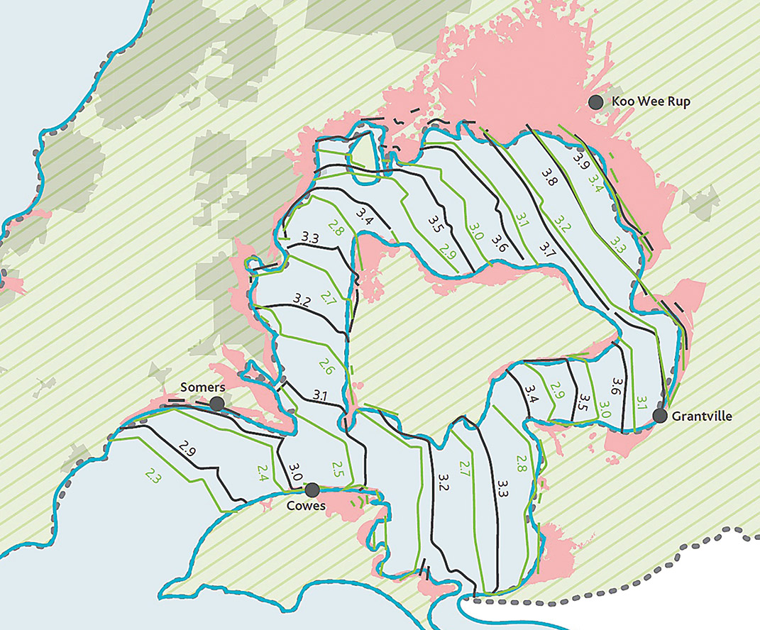
The study area includes all shorelines of Western Port and French Island, as well as the northern shorelines of Phillip Island from Newhaven to Seal Rocks.
The modelling shows that properties are protected by steep foreshores between Flinders and Somers, although changes to the shoreline “could be more extensive change than previously experienced into the future”.
However, “a significant number of non-rural properties” between Balnarring Beach and Hastings would be affected by the end of the century.
Ms Zouzoulas said affected property owners could object to the overlay being applied to their land. “If council decides not to pursue the amendment there is significant risk [that] developers … will be required to make expensive and time consuming design changes to projects at later stages in the development process, including up to the building permit stage.
“Council may also be left at risk for not taking appropriate action to limit the impact of an identified potential hazard to property and human life.”
When the report was first released in 2015, DELWP regional manager Rod Anderson said it brought together “the best historical knowledge of the Western Port coastline with detailed modelling and projected sea level rise data for the years 2040, 2070 and 2100” (“Risks rise with water levels” The News 9/6/15).
“The modelling from the assessment will help land managers and owners in Western Port to make decisions about how to prepare and respond to climate risks along the coast.”
Mr Anderson said the study’s results would “influence future planning decisions, emergency management frameworks, local infrastructure maintenance, and regional climate adaptation planning” by all levels of government.
“It will also be used to continue conversations so that we can better understand community values and priorities in Western Port, and to identify opportunities for collaborative action on climate change.”
First published in the Western Port News – 21 November 2017