

Close Menu
  • Home
  • News
  • Sport
  • Entertainment
  • Local Lives & Landmarks
  • Contact Us
  • Advertise With Us
  • About Us
  • Subscribe
  • Read Our Newspapers Online
    • Read the Latest Western Port News
    • Read the Latest Mornington News
    • Read the Latest Southern Peninsula News
    • Read the Latest Frankston Times
    • Read the Latest Chelsea Mordialloc Mentone News
  • Competition
  • Home New
Facebook X (Twitter) Instagram
Monday, July 13
Facebook X (Twitter)
MPNEWSMPNEWS
  • Home
  • News
  • Sport
  • Entertainment
  • Local Lives & Landmarks
  • Contact Us
  • Advertise With Us
  • About Us
  • Subscribe
  • Competition
Breaking News
MPNEWSMPNEWS
Home»News»Looking into climate change and the bay’s future
News

Looking into climate change and the bay’s future

By Keith PlattMarch 4, 2019Updated:July 16, 2024No Comments3 Mins Read
Facebook Twitter LinkedIn Reddit Threads Email Copy Link
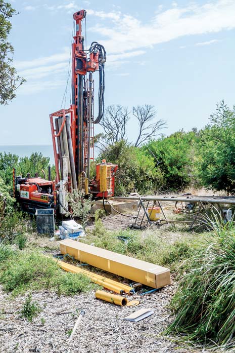
Three holes have been drilled above Mt Martha Beach North to help monitor movement within the cliffs. A tube inserted into the borehole will allow the Department of Environment Lands Water and Planning to measure movement in the cliffs, which have crumbled in several places over the past few years. Rocks were placed at the bottom of the cliffs later last year in a bid to prevent further erosion by the sea. DELWP Port Phillip Program Manager Land and Built Environment John Downs said the cliff top bores were “part of the ongoing works at Mt Martha to monitor and evaluate the effectiveness of the recent emergency revetment”. Stress cracks are evident in the bitumen on the Esplanade just south of Alice Street, near the first borehole.
Share
Facebook Twitter LinkedIn Pinterest Email
Three holes have been drilled above Mt Martha Beach North to help monitor movement within the cliffs. A tube inserted into the borehole will allow the Department of Environment Lands Water and Planning to measure movement in the cliffs, which have crumbled in several places over the past few years. Rocks were placed at the bottom of the cliffs later last year in a bid to prevent further erosion by the sea. DELWP Port Phillip Program Manager Land and Built Environment John Downs said the cliff top bores were “part of the ongoing works at Mt Martha to monitor and evaluate the effectiveness of the recent emergency revetment”. Stress cracks are evident in the bitumen on the Esplanade just south of Alice Street, near the first borehole.

The CSIRO is leading studies into the likely effects of climate change along the Port Phillip coastline.

“This project is an important piece of the puzzle in understanding what climate change means for Victoria’s natural and built environments,” Department of Environment, Land, Water and Planning (DELWP) project manager, Dr Tamara van Polanen Petel said.

The department is one.

The project – which involves government departments and bayside municipalities – will assess the extent of three key coastal hazards: inundation, coastal erosion, and groundwater change – under several climate change scenarios. 

“We know that climate change is happening, and we know that it can create coastal hazards,” Ms van Polanen Petel said.

“What we don’t currently understand is the extent of those hazards and the kind of impacts we will see along the coastline.”

Ms van Polanen Petel said climate change could lead to flooded roads, eroded cliffs and “inland waters becoming saltier”.

“It’s important that this modelling work happens so that land managers, including government departments and councils, can consider how best to plan for, build and manage coastal areas in the years to come.” 

The Port Phillip Bay Coastal Hazard Assessment is the fifth assessment of its kind in Victoria, with similar studies being completed for Western Port, Port Fairy, Bellarine/Corio Bay and Gippsland Lakes/90 Mile Beach.

The CSIRO will draw on data from across government, industry and research sectors with a view to completing the assessment early next year. 

Ms van Polanen Petel said DELWP is working closely with 10 bay-area councils – including Frankston and Mornington  Peninsula – Parks Victoria, Melbourne Water, the bay’s two catchment management authorities, the Association of Bayside Municipalities and traditional owners.

First published in the Southern Peninsula News – 5 March 2019

Related Posts

Arthurs Seat ceremony remembers wartime bomber crash

July 13, 2026

Arrest Made After Criminal Damage at Hastings Police Station

July 10, 2026

Rotary recognises Mount Eliza bookshop for neurodiverse inclusion

July 9, 2026

Planting to protect wildlife at Sunshine Reserve

July 8, 2026
Add A Comment

Comments are closed.

Peninsula Essence Magazine – Click to Read
Peninsula Kids Magazine – Click to Read
Letters to the Editor
Property of the Week

8 Birdwood Avenue, Mornington.

Property Of The Week May 19, 2026
Council Watch

Shire to pull out of aged care services

June 11, 2026

Ratepayers foot the bill for public waste costs

April 20, 2026
100 Years Ago This Week

‘The Standard’ presents souvenirs to councillors

July 9, 2026
Menu
  • Home
  • News
  • Sport
  • Entertainment
  • Local Lives & Landmarks
  • Contact Us
  • Advertise With Us
  • About Us
  • Subscribe
  • Competition
About

Established in 2006, Mornington Peninsula News Group (MPNG) is a locally owned and operated, independent media company.

MPNG publishes five weekly community newspapers: the Western Port News, Mornington News, Southern Peninsula News, Frankston Times and Chelsea Mordialloc Mentone News.

MPNG also publishes two glossy magazines: Peninsula Essence and Peninsula Kids.

Facebook X (Twitter)
© 2026 Mornington Peninsula News Group.

Type above and press Enter to search. Press Esc to cancel.